Hurricane Lee’s rapid Category 5 intensification sparks concerns for Eastern U.S. Impact, experts monitor closely for potential landfall and storm path
Credit: Google | Hurricane Lee (Accu weather)
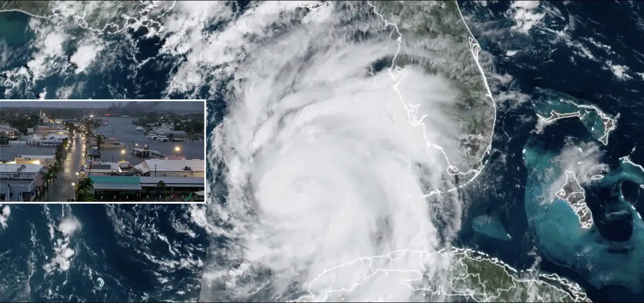
In a meteorological whirlwind, Hurricane Lee has swiftly transformed into a formidable Category 5 storm, escalating from a Category 1 status just hours earlier. With maximum sustained winds reaching an astonishing 130 mph, Lee is poised to make an impactful journey across the Atlantic, with its sights set on the Eastern Caribbean and possibly the U.S. East Coast.
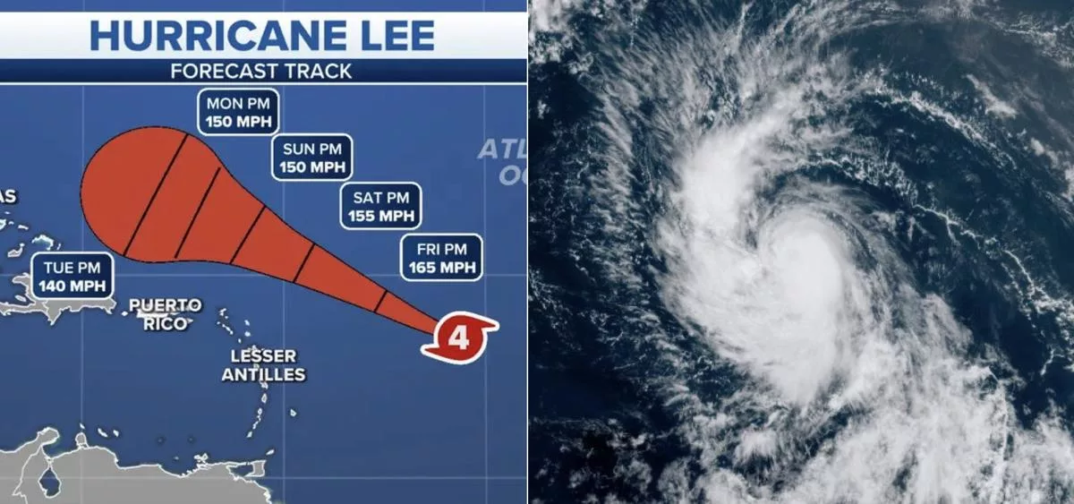
The National Hurricane Center’s 5 p.m. EDT advisory has issued a grave warning, predicting further strengthening in the immediate future. While fluctuations in intensity may occur, Lee is expected to maintain its status as a potent major hurricane well into the following week. Positioned approximately 780 miles east of the northern Leeward Islands, Lee’s trajectory promises to deliver dangerous surf and rip currents to the northern Caribbean on Friday, followed by potential effects on the United States beginning Sunday.
Hurricane #Lee has explosively intensified into a 130 mph Category 4 storm.
— MyRadar Weather (@MyRadarWX) September 7, 2023
The latest @NHC_Atlantic forecast has Lee strengthening into a 165 mph Category 5 hurricane tomorrow. pic.twitter.com/2tSsi2Y7dj
What makes Lee’s rapid intensification particularly noteworthy is its acceleration by an astonishing 50 mph in the last 12 hours, courtesy of the warm Atlantic waters and calm upper-level winds. Forecasts indicate that Lee’s winds could peak at a staggering 160 mph, officially reaching Category 5 strength as it approaches the eastern Caribbean.
One pressing question emerges: how close will Hurricane Lee get to the U.S? The answer hinges on various atmospheric factors, including the Bermuda High’s influence and the position of the jet stream. Presently, the Bermuda High stands strong, keeping Lee on a west-northwestward trajectory. As the high pressure dissipates next week, Lee is expected to shift northward.
The interaction between Lee and the jet stream will dictate the storm’s proximity to the U.S. coast. Two scenarios loom: If the jet stream aligns with the East Coast, it could shield the U.S. from Lee’s approach, though Bermuda may still be at risk. Conversely, if the high pressure remains robust and the jet stream sets up farther inland, portions of the Eastern U.S. could face a closer encounter with Lee.
Meanwhile, in a parallel development, Tropical Storm Margot has emerged in the eastern Atlantic, west of the Cabo Verde Islands. With current winds of 40 mph, Margot is anticipated to become a hurricane over the weekend. Fortunately, its forecasted path keeps it far from any land areas as of now.
While the exact trajectory and impact of Hurricane Lee on the U.S. remain uncertain, experts agree that vigilance is essential. The hurricane’s movements will continue to be monitored closely in the coming days, with the possibility of it becoming a threat to the East Coast looming at least a week away.
As the world watches the dynamic developments of Hurricane Lee and the potential challenges it poses to the Caribbean and the United States, meteorologists and authorities are ready to respond swiftly and decisively to protect communities in its potential path.
RELATED NEWS
WEB STORIES FOR YOU


Stay connected with Today On Globe for the latest Global Issues and News Updates.
Explore more related articles at [TOG News / TOG Article]